Recent posts
Rome - 14 things not to miss
 My personal advise on what to do and see in Rome
My personal advise on what to do and see in Rome
Mt Egmont and King Edward Park
 Mt Egmont seen from the King Edward Park playing fields in Stratford
Mt Egmont seen from the King Edward Park playing fields in Stratford
Stratford Glockenspiel
 The Stratford Glockenspeil in Taranaki
The Stratford Glockenspeil in Taranaki
The Antelope - the dog friendly pub
 The Antelope - your local, dog friendly, beer friendly pub
The Antelope - your local, dog friendly, beer friendly pub
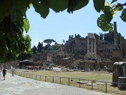
Ancient Rome - 8 must see highlights
 Must see ancient monuments around Rome
Must see ancient monuments around Rome
Antwerp - de Kathedraal
 Historical information about the gothic Antwerp Cathedral
Historical information about the gothic Antwerp Cathedral
Antwerp - what to do, see, stay and eat
 What to see, where to stay and eat in historic Antwerp
What to see, where to stay and eat in historic Antwerp
Austria - recommended places to stay
 Recommended hotels in Vienna, Salzburg and Bregenz
Recommended hotels in Vienna, Salzburg and Bregenz